
Zuma Beach
105 acres of white sand, lifeguard towers, and premier body surfing on Malibu’s widest public shoreline.
Southern California classic →
From Big Sur’s sea cliffs to Santa Cruz surf breaks, La Jolla’s wildlife-rich coves, and Malibu’s sun-drenched sands — California’s 840-mile Pacific coastline delivers some of the world’s most spectacular beach experiences.
Explore the GuidePlan a smarter coastal trip with california.in: Malibu, La Jolla, Huntington Beach, Santa Barbara, Big Sur, Carmel-by-the-Sea, Northern California shores, surfing from beginner to expert, coastal wildlife, and practical beach safety tips along the full Pacific Coast Highway.
Jump to the stretch of coast that matches your trip — classic Southern California sand, Central Coast drama, wild northern headlands, or the state’s legendary surf culture.
California’s coastline is one of the great natural assets of North America — an 840-mile span of Pacific shoreline that encompasses nearly every coastal landscape imaginable, from sandy, tropical-seeming coves to foggy, seal-crowded rocky headlands.
The coast is shaped by the meeting of the Pacific Ocean with the North American continent along one of Earth’s most geologically active boundaries. The Pacific Plate grinds against the North American Plate along the San Andreas Fault system, driving the earthquake activity California is famous for and uplifting the coastal ranges that give the shoreline its dramatic topographic character.
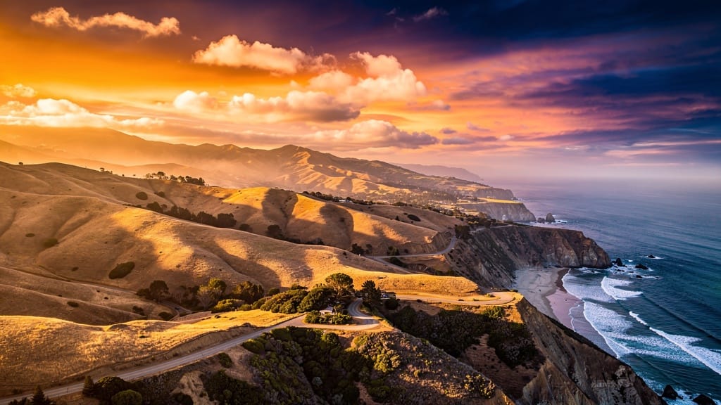
The result is extraordinary variety. From San Diego north to Point Conception at the western tip of the Santa Barbara Channel, Southern California is defined by wide sandy beaches backed by coastal bluffs and low mountains — the classic California beach image. North of Point Conception, the character changes: the ocean grows colder under the California Current, weather becomes more variable, and the landscape turns increasingly dramatic as the Santa Lucia Mountains plunge into the sea along Big Sur.
The Pacific Coast Highway (Highway 1) is the most scenic driving route along the California coast, hugging the shoreline from Dana Point in Orange County north through Malibu, Santa Barbara, Big Sur, Carmel, and on to Bodega Bay north of San Francisco. Driving the full length of Highway 1 remains one of the great American road trips — a journey through constantly shifting landscapes, with the Pacific glittering to the west and mountains or hills rising to the east.
Malibu’s coastline stretches 27 miles along the Pacific — one of California’s most coveted and breathtaking stretches of shore. It is perhaps the most mythologized coastline in the world: a ribbon of Pacific beach north and west of Los Angeles that has defined California beach culture since the 1950s. The Gidget films, early Beach Boys records, and a century of Hollywood productions fixed Malibu in the global imagination as golden sand, perfect waves, sun-drenched celebrities, and the Pacific in all its blue magnificence.
The reality is more interesting and more varied than the myth. Incorporated as a city in 1991, Malibu runs along PCH from the Ventura County line in the north to the Los Angeles city limits in the south. It includes everything from the famous celebrity estates of the Malibu Colony — a private gated community where the beach has been closed to the public for 70 years, despite ongoing legal efforts to establish public access — to wild, undeveloped coastal bluffs reachable only by hikers.
Zuma Beach, at the northern end of the Malibu coast, is the widest and sandiest of the Malibu beaches — a 105-acre stretch of white sand backed by dramatic coastal bluffs, with four lifeguard towers and some of the best body surfing conditions in Southern California.
El Matador State Beach, a few miles north of Zuma, is the most dramatic of the Malibu sea-stack beaches: a rocky cove where enormous stone arches and sea stacks rise from the waves and sea caves can be explored at low tide. Reach it via a steep wooden staircase down the bluff. The photographic opportunities — especially at sunset, when the rocks cast long shadows across the sand — are extraordinary.
Malibu Lagoon State Beach, at the mouth of Malibu Creek, is one of the most ecologically important coastal habitats in Southern California — a lagoon and estuary where dozens of species of shorebirds and waterfowl feed and nest, and where the Pacific meets one of the region’s last functioning coastal wetlands.
105 acres of white sand, lifeguard towers, and premier body surfing on Malibu’s widest public shoreline.

Stone arches, sea caves at low tide, and unforgettable sunset light reached by a steep bluff staircase.

A vital estuary at Malibu Creek’s mouth — shorebirds, waterfowl, and rare Southern California wetland habitat.
La Jolla — “the jewel” in Spanish — is San Diego’s most celebrated coastal community and one of Southern California’s most beautiful shoreline destinations. Its coves, sandstone cliffs, clear water, and abundant marine life create a beach experience that feels refined, wild, and walkable all at once.
La Jolla Cove is the signature stop: a compact, protected pocket of sand and rock framed by cliffs, popular for snorkeling, kayaking, and watching sea lions and harbor seals haul out on the rocks. Nearby La Jolla Shores offers a longer sandy beach with gentler conditions suited to families, beginner surfers, and stand-up paddleboarders, while the undersea canyons just offshore attract divers and marine researchers.
The surrounding village blends galleries, cliff-top paths, tide pools, and ocean-view dining. Tide-pooling along the sandstone shelves reveals anemones, crabs, and small fish at low tide — one of the most accessible wildlife encounters on the Southern California coast. Respect marine mammal distance rules and stay on public paths along the bluffs.
Protected water, cliff scenery, snorkeling, and sea lions on the rocks in the heart of the jewel.
A broad sandy beach with softer waves for families, lessons, kayaks, and easy Pacific days.

Explore low-tide life on sandstone shelves and walk cliff paths with sweeping ocean views.
Huntington Beach has earned its Surf City USA identity with a long, wide strand, a historic pier, consistent breaks, and a beach culture built around surfing contests, boardwalk energy, and Pacific sunsets. It is one of the most approachable big-beach destinations in Southern California — easy to reach, well staffed by lifeguards, and lively without losing its connection to the water.
The Huntington Beach Pier anchors the scene, stretching into the Pacific as a landmark for surfers, strollers, and evening light. Broad sands support volleyball, long walks, and family setups, while nearby streets deliver the casual surf-town mix of rentals, casual dining, and coastal nightlife.
For travelers comparing Orange County beaches, Huntington stands out for reliability: room to spread out, a strong surf identity, and a classic California beach day that works for beginners watching the lineup as well as experienced riders chasing clean sets.
Santa Barbara faces south along a rare east–west stretch of California coast, catching a softer light and a Mediterranean mood that earned it the nickname “the American Riviera.” Palm-lined shores, the Santa Ynez Mountains rising immediately behind town, and a graceful Spanish Colonial Revival core combine beach time with wine country, dining, and harbor life.
East Beach and lead-up strands near the harbor offer classic sandy recreation with mountain backdrops, while the waterfront path links the pier, marina, and open shore. Stearns Wharf remains a signature stroll over the water. Just beyond town, coastal drives toward the Gaviota Coast and Channel Islands views reinforce why Santa Barbara is a favorite midpoint on any Southern-to-Central Coast itinerary.
Use Santa Barbara as a base for slower coastal days: morning beach walks, afternoon wine-country side trips, and sunset returns to the Pacific. Point Conception to the west marks the climatic turning point where colder northern waters and a wilder coastline begin in earnest.
Sandy recreation, mountain views, marina energy, and an easy waterfront path for walking between pier, shore, and town.
A classic wooden pier experience over the Pacific — ideal for ocean air, photos, and pairing beach time with the historic downtown.
Blend beach mornings with nearby wine country, Spanish Colonial streets, and scenic drives along the Gaviota Coast.
Big Sur is where California’s coast becomes legend. Here the Santa Lucia Mountains drop almost straight into the Pacific, creating a shoreline of towering cliffs, hidden coves, redwood canyons, and viewpoints that define the Central Coast. It is less a single beach town than a continuous drama of rock, fog, spray, and sky along Highway 1.
Beaches in Big Sur are often pocket coves reached by short trails or steep paths, with cold water, powerful surf, and scenery that rewards slow travel. Stops along the route reveal arching bridges, roadside overlooks, and state park access points where the mountains meet the sea in full force. Conditions change quickly; storms and slides can affect road access, so check Highway 1 status before you go.
Plan Big Sur as an experience rather than a checklist: leave time for pullouts, coastal walks, and the shifting light that makes this stretch one of the most photographed shorelines on Earth. Pair it with Carmel to the north or the wider Central Coast for a balanced trip.
Carmel-by-the-Sea offers one of California’s most graceful beach settings: a wide crescent of white sand framed by cypress-studded slopes, a storybook village of cottages and galleries, and easy access to the wilder beauty of Point Lobos and the Big Sur coast beyond.
Carmel Beach is the centerpiece — soft sand, dog-friendly stretches, dramatic sunsets, and water that stays firmly in the cool Central Coast range. The village above the shore grew from an early artist colony into a carefully preserved coastal retreat of courtyards, boutiques, and ocean light that still feels intimate despite its fame.
Nearby, scenic drives and short coastal trails connect Carmel to Carmel River State Beach, the rocky drama of Point Lobos State Natural Reserve, and the Seventeen Mile Drive area toward Monterey and Pebble Beach. Together they form one of the richest compact coastal clusters in the state for walkers, photographers, and travelers who want beach time without a sprawling resort strip.
A luminous sandy crescent below the village — cypress silhouettes, cool water, and legendary Pacific sunsets.

Galleries, courtyards, and cottage architecture a few steps from the sand — Carmel’s creative coastal character.
Rocky coves, marine life, and trail overlooks linking Carmel to the wilder Central Coast.
North of San Francisco, California’s beaches turn wilder, cooler, and more elemental. Expect rocky headlands, wind-shaped dunes, driftwood-strewn strands, redwood-backed coves, and ocean temperatures that average near 58°F. The payoff is solitude, storm-watching drama, and landscapes that feel closer to the Pacific Northwest than to Malibu.
From Marin’s cliff trails and Point Reyes beaches to Sonoma Coast state beaches, Bodega Bay, Mendocino headlands, and the far north toward Humboldt, the northern shore rewards layered clothing, flexible plans, and respect for sneaker waves and steep drop-offs. Fog can erase the horizon by afternoon; clear mornings are often the most magical.
These beaches are ideal for hikers, wildlife watchers, photographers, and travelers chasing atmosphere over swimming. Combine them with Highway 1, redwood parks, and coastal towns for a Northern California itinerary defined by weather, geology, and open space rather than boardwalk crowds.
Long beaches, cliff trails, tule elk country, and Pacific overlooks within easy reach of the Bay Area.
Rugged state beaches, sea stacks, and Bodega Bay gateway energy along a cooler, wind-bright shoreline.
Headland paths, driftwood beaches, redwood canyons, and far-north drama toward Humboldt’s wild coast.
California’s surf culture was born on these beaches. Whether you want a first lesson in soft Southern California whitewater or a pilgrimage to storied breaks from Santa Cruz to San Diego, the coast offers a full spectrum of conditions, communities, and seasons.
Look to gentler beach breaks and lesson hubs around La Jolla Shores, Huntington, and other lifeguarded Southern California strands.
From Malibu’s long rights to Santa Cruz energy and San Diego county lineups, California’s named breaks shaped global surf culture.
Southern averages near 68°F; northern water near 58°F. Wetsuits are normal much of the year outside peak southern summers.
Piers, local shops, contests, and boardwalk life turn Huntington, Santa Cruz, and dozens of coastal towns into full surf destinations.
California’s public coastline includes 420+ beaches and 15 state marine reserves. Enjoy wildlife and big surf with the same practical care you would bring to any wild Pacific edge.
Expect sea lions, harbor seals, shorebirds, and seasonal whale activity offshore. Give marine mammals wide space, never feed wildlife, and use binoculars instead of approaching haul-outs at places like La Jolla and Malibu Lagoon.
Swim near lifeguards when available, learn local rip-current patterns, and treat cold water with respect. Northern and Big Sur beaches can have sneaker waves, steep shores, and unstable cliffs — keep distance from edge drop-offs.
Check tide charts for caves and tide pools, arrive early for parking at famous lots, pack sun protection even on foggy days, and verify Highway 1 conditions before Big Sur or remote northern drives.
California’s coast is a public trust, but access points, stairways, and parking vary. Stay on legal paths, respect private property boundaries, pack out trash, and leave tide-pool creatures where you find them.
Pair this beaches guide with city pages, national parks, and broader trip planning on california.in so your coastal days fit a complete Golden State itinerary.
Return to the main 2026 travel guide for destinations, experiences, itineraries, and essentials.
Connect Malibu and Santa Monica-area coast days with Hollywood, neighborhoods, and LA planning.
Use the Bay Area as a launch point for Marin, Point Reyes, and Highway 1 north or south.
Balance beach time with granite, redwoods, desert, and the state’s nine national parks.
Link Dana Point to Bodega Bay on Highway 1 with stops in Malibu, Big Sur, Carmel, and beyond.
Combine Santa Barbara or Northern California beach days with nearby vineyard and food detours.
Subscribe for new destination guides, seasonal coastal recommendations, practical planning advice, and California travel inspiration.